Wednesday, February 28, 2018

Yosemite National Park


Yosemite National Park is a special place for Linda and me. Some 58 years ago we first met at a high school leadership conference held here.  this trip was short and so we only were able to visit the main valley attractions. On an earlier anniversary we spent a week hiking a part of the John Muir Trail which starts in Tuolume  Meadows and winds around the back of Half Dome descending into the Yosemite valley.
 
This is the view that greets you upon leaving the tunnel which feeds into Yosemite valley.

the two of us at Bridal Veil Falls.


The park center has this 3D map of the entire valley. the tunnel referenced above is on the right side about midway ( the yellow line that looks like it is dotted)

El Capitan with Half Dome in the distance


another view of El Capitan

El Capitan from its base. this rock is a popular rock climbing site with some climbers opting to stay over night in hammocks hung from the face. the climb to the top is about a two-three day adventure.

Yosemite Falls  this is a three stage falls and you can see the stages; first the wider section at the top, the narrow stream mid way and the final stage at the small  section just above the tree line.


San Joaquin river reflects the mountains


a doctored (romantic?) shot of the valley

this hotel was previously known as the Awanee but as a result of a change in vendors in the National Park it is now called the Majestic Hotel. built in 1923 it has a long and colorful history of hosting presidents and historic figures.
this is the main dining room at the Awanee.


the main lounge area


Registration desk


the park service has introduced a free shuttle bus system that goes to all areas of the park valley. once you find a parking space there is no reason to move the car with over 4 million visitors each year the park is very busy all year long.


one of the many streams that are produced by the waterfalls and feed into the San Jouquin river.


the continuing drought has killed several trees which have been cut as safety hazards.  the wood is cut up for use in fires by staff and visitors.

the 1997 flood was a disaster for the valley wiping out many buildings and exhibits.  this sign indicates the depth of  flood waters. much of  the damage was the result of log dams building up in the narrows of the canyon and then breaking free sending tons of debris down the valley.


this black and white is my homage to Ansel Adams who created several photos of iconic features of the Yosemite area.  If you have enough imagination and stare long enough you might be able to see an indian woman's face on Half Dome's face. she is guarding the valley from evil.


a part of my attempt to imitate Ansel Adams

Sunday, February 25, 2018

volunteering at Bodie Lighthouse, North Carolina

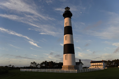
this past summer Linda and I volunteered with the National Park Service at Bodie Lighthouse in the outer banks of North Carolina.  Bodie is a preserved lighthouse and so it remains much as it was when being manned by a light keeper.  opened in 1872 it filled a void in the number of lighthouses along the eastern coast of the USA. the demand for a lighthouse in this area came from the ship owners and captains who sailed from the industrial areas up north to the agricultural areas in the south.  this era of reconstruction followed the civil war, which was responsible for the destruction  of other major transportation channels, ocean vessels assumed a very important role in getting goods and supplies to and from the previously warring factions. 

the building shown here is the third light to be erected in this area. the first was built too close to the ocean and after a short time fell over and collapsed.  the second one was a victim of the civil war being blown up by retreating confederate soldiers. fortunately, the Fresnel lens was salvaged and reused in other locations. this third attempt was properly located away from the shore and built by the contractor who had just recently finished the light house  at Cape Hatteras. using double wall design the base is over 6 feet think tapering to over 2 feet at the top. we climbed the 219 steps 2x or 3x each day assisting visitors and answering their questions.


each light house has its own light signature as well as a distinctive color.  Bodie started out as a solid light always on and later when all lights were re coded took on its current and distinctive 3 shorts on followed by a long off.


the light was not open to the public for many years ans as a result suffered from a lack of maintenance.  when first opened in 1973 the stairway and hand rails were in very poor shape suffering from extensive rust and in several areas collapse.  the Park Service removed the stairs and the other cast iron supports and braces giving them to a pattern maker in New York for him to replicate the items.  they first made patterns of each piece and using the old cast iron along with new iron recast the stairs and rails. the recast pieces were then installed in their original places for public use.


looking up the middle of the lighthouse the delicate spiral staircase is a work of art.


because the building tapers, the stairs must taper also. the double curve demonstrates the skill of the workmen and craftsmen in the late 1800's.


each stair tread was patterned and recast for additional strength.


from the top of the light the old light keeper's house is visible.

light keepers were required to live on site. they were provided with housing, food and stipend for their services. many of them brought their families, including children, to live with them. from Bodie wives and children would board a small boat and row over to the mainland to go to school. Later when roads were graded to the light, the children would ride in a buggy to school.


on a clear night the stars make a brilliant backdrop for the light house.


morning sun at the light.

the Fresnel lens, invented by a french engineer of the same name, was the most effective lens used in lighthouses.  using this engineered lens the light from oil lamps could be seen 19 mile out to sea,  this warning beacon saved  hundreds of lives and millions of dollars of goods. 


today, instead of oil lamps, the lighthouses use 1000watt electric bulbs shown here. the light signature is obtained by turning the power on and off.

the cast bronze brackets hold and angle the prisms for maximum efficiency.  during the reconstruction of the building this lens was dissembled, cleaned and reinstalled. the lens in  use today is the same one installed in 1872.


this marker identifies the location and commemorates its dedication.  the name is misspelled. proper spelling is Bodie, based on old records and family confirmation. 


The oil room and keepers office is in the small building attached to the light.


brief description of how a light works.


sunsets were often spectacular

Mammoth Cave Kentucky

our trip to the Mammoth Cave National Park in Kentucky proved to to be more interesting than initially thought.  The enormous size and the variety of geological and human effects made our visit.  there are guided several trips into the cave and each explores a different section. 


the visitor center has this 3D depiction of the main cave area.  the cave was formed thousands of years ago by Green River flowing through and eroding the limestone deposits present in this area.  the sandstone deposits closer to the surface are harder and so they formed the cap for the cave.


additional to the 3D model the Park Service has this highlighted map which shows the full extent of the currently explored cave areas. there are over 400 miles of explored cave with spelunkers continuing to explore and add to the cave boundaries. 


this is the main entrance to the cave. descending the steps you can feel the cool air flowing up and out.

the main area is well marked with well defined paths to follow. this area is over 20 feet tall.

running several hundred feet and rising several stories high the name Mammoth Cave is aptly named.


the rubble seen here is from a collapse of the ceiling limestone.  the flat surface shown is the hardened sandstone.

the limestone does not always fall in small pieces. this huge rock fell from what looks like a pocket in the ceiling.


explaining why certain formations exist is impossible. this upside down mushroom formation is one of those. our ranger guide was unable to explain or even offer a theory as to why this was not washed awy when the the river flowed through this area.

this sigh was a warning to early explorers for the very narrow channel coming up.  the early guides had a strange sense of humor.


no one in our group was able to navigate this passage without touching both sides of the rocks.


before the Park Service took over the cave early explorers were led by entrepreneurial guides who would allow their charges to  use the smoky lanterns as pens leaving their mark on the ceiling and the walls.  this is euphemistically called 'historical graffiti' and is protected by the park rangers.


I wonder what Nick would think of today's guided tours?


early tourists came from all over the USA. O. Mull apparently came from Virginia.


the water channels between levels were supposedly formed by the river forming eddies and whirlpools which bored round passages as shown here.


these vertical channels could extend several feet.  this one appeared to be over 300 feet .


early Native Americans and later miners would visit the cave to harvest its nitrate for use in gun powder and other explosives.


one of the downsides of our touring this cave is the introduction of moisture and human waste into the cave. the increased moisture and added light from explorers all moss and lichen to grow on the cave walls.  the green showing in this photo is a moss variety.


gypsum is another mineral found in the cave.  these 'gypsum flowers' exist in several areas where the conditions are right. their unusual shape is unexplained. our guide said that these flowers grow very slowly and these were likely several hundred years old


our guide turned off all installed lights in our area and then used this old miners lamp to show what the early explorers would have seen. when he turned this off the darkness was absolute. film left exposed for 24 hours showed no exposure whatsoever. 

early explorers weren't concerned with recycling and left their trash.

a clearer picture of the limestone sandstone boundaries.


unlike many caves Mammoth Cave does not have an abundance of stalactites and stalagmites. this area is one of the exceptions.  the cascade of calcite drip-stone flows from the thin cracks between the sandstone and the limestone. the very thin vertical lines shown to the right-center   above are actually pencil thin, and very very fragile, mineral  deposits that run from ceiling to floor.

when you go down you must go back up.


not  all paths out required climbing 10-15 story stairs. one of our tours was in and out through the main entrance.

in an attempt to reduce the impact of man on the fragile nature of the cave the Park Service has installed air locks for tours into the deeper and more sensitive areas.

before the roads into this area were constructed tourists were transported via the Mammoth Cave railroad.  Coal fired steam engines (in black) would pull passenger cars (in red) to the area where guests would stay in tents.